The Most Beautiful Villages and Towns of California
a book you want to page thru at the Bookstore, written by Joan Tapper
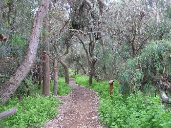
Hit the bookstore and find this book. "The Most Beautiful Villages and Towns of California." Written by a Natl Geographic editor. Page through it. You might just find an idyllic place to live with fresh air, deep dirt! If you want to build a farm, build it ONE STORY as this IS the earthquake state!Now, let's seek out the choice area to live. Take a look at the map, below. It's topographical, shows you the climate of various farm areas of California
http://phrelin.com/3Cals/images/caltopo.jpg
The primo land is probably that huge vertical valley, south of San Francisco bay, next to that PROMONTORY called the PENINSULA. See that VALLEY slightly inland descending like a fissure from the Monterrey Peninsula. It is called El Camino Real. The ROYAL ROAD. Aside from the very costly CARMEL VALLEY, that is probably the most primo area of CHEAPER land in the state.But another is over there on right side, AN INCH above word "MOJAVE" that green snakey valley? DIRT CHEAP LAND!
El Camino Real includes the counties of San Jose, Santa Clara, Santa Cruz, San Benito, Monterey and San Luis Obispo. While decidedly different, the identities of these counties are related by a distinctly Western history, the frequent use of language reflecting their origin as Spanish settlements, and their experiences of change, adaptation and re-invention. Monterey was the capital and center of commerce in the Spanish, Mexican and early American periods, while recently that position has shifted north to Silicon Valley. The most original El Camino Real, or King’s Highway, was first the route of an expedition of Spanish exploration from San Diego to Sonoma in 1769 and later became the crucial link between the early California missions which were the original venture of Christianity into the far west. In some places highway U.S. 101 follows quite closely this old road between missions, but in other places it varies greatly from the original route. Nevertheless it remains the most common historical link along the central California coast, and motorists who drive from San Diego to San Francisco will pass through the area comprising this diocese and may see the mission bell markers which identify the paths of the early padres.
U.S. citizens came west early in the 19th century, marrying Spanish heiresses, enjoying the life of the great rancheros, and taking leadership in their new country. In the late 1840’s gold seekers bypassed this region, which was rich in land and sea but poor in nuggets. As a result, ranching, agriculture and fishing became the foundations of the economy. For the succeeding 100 years, the communities of the area grew slowly and comfortably, increasing their life with agricultural wonders. San Jose, the city nearest San Francisco, remained a small town surrounded by thousands of acres of apricots and prunes until the 1950’s. The coastal communities maintained a robust economy based on fishing.
The post-World War II boom turned the Santa Clara Valley into a vast tract of homes, electronic and defense companies, freeways, and urban sprawl. Orchards, vineyards, and truck farms were developed in the neighboring valleys to the south. Most recently, the pressure for housing and the desire to live in a less populated area has produced a new and current land boom in the counties south of San Jose. After the sardine fishing and canning industries collapsed after World War II, the southern counties saw their area give way to the influences of tourism and second home ownership while agriculture in the Pajaro and Salinas Valley continued to flourish. Once again, new elements and dynamics influenced the traditions and the identities of the far-ranging corners
We are Near enough to the city to carry produce to the Pricey Farmers' Markets
in the morning. We pick at six a.m. and by 8AM are at the market. Home by 3PM.
LIFE IS GOOD!The major centers of the state are now metropolitan areas with a continuing movement of people and light industry into agricultural and rural country-sides. Urban problems beset the state that once epitomized the “pot of gold at the end of the rainbow.” Rapid increases to population as a result of immigration from the Middle East, the Pacific Rim as well as South America increase the pressure to assimilate newcomers and adapt to new influences. All of our communities expect significant economic and social changes in the next 20 years.
THERE ARE OTHER NICE CORNERS!
California's picturesque villages and small towns and its stunning landscape, from rugged sierras and fog-laced headlands to golden sand beaches and rolling oak-studded ranchland...all of it available for a two acre farm that could supply all your needs.
California is nicknamed "The Golden State," and though the name applies literally to the color of its state flower, the golden poppy, it is also a metaphor for the hopes and dreams that have lured generations of settlers. There are villages that grew up around the famed Spanish mission trail, and communities that boomed because of Gold Rush fever. There are places whose natural beauty nurtured artists and writers, and fertile valleys that were home to vintners and cattlemen.
The state is known for reinventing itself, yet a surprising number of its towns and villages still offer charming glimpses into its history and heritage. Google up a MAP OF THE different COUNTIES that California has...with their NAMES, so that you can view many, then google smaller, more local maps. "Their architecture may be quaint, historic, or gracious and their physical settings may take the breath away, but they are also vital communities, prized for their small-town values, their lifestyle, food, and wine. This book showcases the most beautiful villages and towns of California in Nik Wheeler's stunning photography and Joan Tapper's perceptive commentaries. These evoke not just historic houses, but also streetscapes, parks, and physical surroundings." says the webpage on this book which is divided into four regions: Northern California Coast, Northern California Mountains and Valleys, Central and Southern California Coast, and Central and Southern California Mountains and Valleys. The best of these would be Vista, Escondido (avocado country) in the San Diego region, in valley or low lying areas, and Idyllwild in high mts, clean air, snow every yr, cherries apples do well there and LILAC. Sell lilac to flower markets, there's a good living.
Google around you will find photographic essays on the wine country, missions, and ghost towns, plus essential information for tourists on places to stay and to eat. 323 color photographs.
URL BELOW is A TOPOGRAPHICAL MAP of CALIF, by NASA. The real thing, colored up.
Note the valley on right side of state near Nevada, a long valley, running vertically. Might be nice there. Certainly is REMOTE hence very cheap! Douse a few lots.http://www.jpl.nasa.gov/images/earth/usa/cal_mosaic_browse.jpg
But the most beautiful village of all? The designer of a small British village lived to l00 so passionate about this was he -- Portmeirion Village GOOGLE those words in quotes For a real treat.<==== BACK TO THE CREATE YOUR OWN FARM INDEX
~^~^~^~^~^~^~^~^~^~^~^~^~^~^~^~^~^~^~~^~^~^~^~^~^~^~^~^~^~^~^~^~^~^~^~^~^~
Our POSTER is ANITA SANDS HERNANDEZ, Los Angeles Writer, Mother of four and career Astrologer. Catch up with her websites TRUTHS GOV WILL HIDE & NEVER TELL YOU, also The FUTURE, WHAT'S COMIN' AT YA! & HOW TO SURVIVE the COMING GREAT DEPRESSION, and Secrets of Nature, HOLISTIC, AFFORDABLE HEALING. Also HOW TO LIVE on A NICKLE, The FRUGAL PAGE.* Anita is at astrology@earthlink.net ). Get a 35$ natal horoscope "my money/future life" reading now + copy horoscope as a Gif file graphic!
<===BACK TO MONEY SECRETS ONLY THE EXPERTS KNOW
<=== BACK TO SECRETS THE GOV DOES NOT WANT YOU TO KNOW
<=== SHOW ME THE FIX INDEX PAGE.
<== SHOW ME THE HAPPY R)EVOLUTION PAGE
<=== BACK TO "GUERILLA CAPITALISM" -- THE SOLUTION!
<=== BACK TO REAL CAUSES OF THE MELTDOWN -- a WEBPAGE
<------BACK TO THE VULTURE SANDWICH, WORLD STARVATION INDEX PAGE
<------ BACK TO HOW TO STEAL A CORPORATION FROM THE STOCKHOLDERS
<=== GUERILLA CAPITALISM FOR YOU AND ME!
<----- BACK TO THE IMPORT EXPORT TRAINING SEMINAR
<----- BACK TO THE LEGACY TRADE SEMINAR
<=== BACK TO TRACKING THE ECONOMY, an INDEX PAGE
<===BACK TO THE ACTIVIST'S EASY BREEZY METHOD FOR EVOLUTION
<=== BACK TO THE EASY, BREEZY, NO WORK AT ALL GARDEN ARCHIVE for Suburban farmers
<===BACK TO THE OPULENT LIFE 101 THOUSAND ARTICLE SEMINAR, FREE, NO REGISTERING REQ'D REPUB ANY OR ALL FREE, GET AD REVENUE!
<=== BACK TO "BE READY FOR THE 20 TRILLION DEBT TO CRASH SYSTEM. GET YOUR FARM NOW. 10 FAMILIES TOGETHER
<== BACK TO ANITA SANDS WEBSITE
